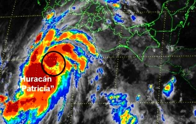
Hundreds of thousands of people are in the path of the strongest hurricane ever recorded as the small but intensely violent storm’s landfall is imminent.
 Hurricane Patricia bears down on Mexico's Pacific coast – as seen from space
The winds of hurricane Patricia howled towards the coast of Mexico on Friday, with hundreds of thousands of people in the path of the strongest hurricane ever recorded.
Patricia is small in surface area but intensely violent in strength. It threatened to be one of the most devastating storms in history as it neared landfall with record sustained winds of 200mph.
More than a third of a million people were in the path of the storm. Mexican authorities have declared a state of emergency.
In the face of winds capable of lifting vehicles and sweeping structures from their bases, the popular holiday resort of Puerto Vallarta and the major port of Manzanillo on the Mexican south-west coast were braced for imminent devastation.
The hurricane was boosted by the El Niño cyclical weather pattern, which has warmed the Pacific waters and whipped up the extreme winds.
The strongest category five winds were swirling in a relatively small radius of five to 10 miles out from the eye of the storm but were likely to have a devastating effect.
The US National Hurricane Center predicted that peak winds of 200mph would be sustained when the storm struck land, which would be the strongest hurricane ever recorded, exceeding super typhoon Haiyan, which struck the Philippines with 195mph winds in 2013.
Patricia will also out-roar historic hurricane Katrina in 2005 and hurricane Andrew of 1992, which hit Louisiana and Florida respectively with incredible force, causing widespread death and destruction.
“With this type of wind the damage is catastrophic. There are very few structures that withstand this,” Dennis Feltgen, a spokesman for the National Hurricane Center in Miami, said on Friday. He warned that buildings would be ripped off their foundations.
On the Mexican coast, residents were scrambling into buses and cars to try to flee inland. Airports, school and public buildings and hotels were closed or battened down into makeshift shelters.
Roberto Ramirez de la Parra, the director of Mexico’s National Water Commission, warned that Patricia had the makings of “the most dangerous storm in history” and urged all residents in its path to seek shelter, because the risk of loss of life was “very high”.
Hurricane Patricia catapulted from a tropical storm to record-breaking monster in just 30 hours from Wednesday night local time.
First it reached the level of the biggest storm ever logged in the western hemisphere and by Friday afternoon it was being referred to by meteorologists as the strongest hurricane on record, although experts warned that measuring the speed of winds inside a hurricane is not a precise science.
Above-average warm water temperatures across a wide swath of the Pacific provided the energy that meteorologists call explosive intensification. The air was much moister than usual, adding yet more energy to the storm, experts said.
At the same time, upper-level crosswinds that can restrain hurricanes were missing for much of Thursday.
“I was really astounded,” said MIT meteorology professor Kerry Emanuel. “It was over the juiciest part of the eastern Pacific.”
El Niño’s fingerprints are all over this, meteorologists agreed. And while it fits perfectly into climate scientists’ projections of what a warming world will be like, they say it is too early definitively to blame climate change for the power of the storm. Environmental monitoring bodies will be watching closely.
In the south-western US, emergency management officials in Texas contending with multiple storm systems were preparing for heavy rains to continue through the weekend and for the widespread flooding that could follow.
Rain fell steadily on Friday through much of the state and was forecast to continue through at least Saturday as one storm system slowly moved eastward. Many parts of Texas, including the metro regions of Austin, Dallas and Houston, could see upward of 12in of rain by Saturday.
Officials were concerned that the current system would be followed by the soaking outskirts of hurricane Patricia after it made landfall in Mexico.
NWS meteorologist Kurt Van Speybroeck said as the hurricane moved inland, the mountains of Mexico “would shred Patricia apart”, but the weakened system would continue moving north and eventually bring another round of rain to Texas before moving into Arkansas, Louisiana and beyond.
“It’s definitely going to be beneficial when it comes to the drought and fire concerns we’ve had over several weeks in Texas,” Van Speybroeck said.
For emergency officials a primary concern was the anticipated widespread flooding. Five months ago, torrential spring storms caused at least 30 deaths.
The Memorial day weekend brought more than 20in of rain to some outlying areas and many homes were either damaged, cut off or swept away by river water south-west of Austin. Around 1,500 homes in the Houston area sustained flood damage.

Las opiniones vertidas por nuestros colaboradores se realizan a nivel personal, pudiendo coincidir o no con la postura de la dirección de Protestante Digital.
Si quieres comentar o